October 6 to 10, 2016
The Great Allegheny Passage
Day 0: Eganville to Keymar
~ Dennis and Stromboli
It was a long, boring drive from Eganville, Ontario to Keymar, Maryland not because the scenery or weather was bad but because I had done it so many times. Actually the weather was perfect and the fall colors ranging from the full artist’s pallet in Ontario to ever increasing shades of green with each mile south. My connection with Keymar and my shuttle host Dennis goes back many years to a time in the 1970s when we were both fresh, green teachers at Baltimore’s Lemmel Junior High. It is a friendship that has spanned decades as well as distances. Dennis and I have shared some strange adventures but unfortunately this time he could only participate as my ride from his house to the GAPCO trailhead in Pittsburgh and my lift from DC back to Keymar. While Amtrak runs a train that would get my bike and me from DC to Pittsburgh, it arrived at nearly midnight and that was a deal breaker for me. Lucky I had my friend who is a Pittsburgh native and who still has family there that he could visit after dropping me off.
I arrived at Dennis’ house in the early evening and just in time to treat him to dinner at Tony’s of Taneytown. They make the best stromboli. Later we sat in his living room shared a few beers and watched a movie. I decided to call for an early night with hopes of getting a good, last rest in a comfortable bed before spending the next few nights in a tent.
Day 1: Keymar to Pittsburgh by Car
~ The Search for the Trailhead ~ Railroading by Bicycle ~ Meeting Superman
The drive from Keymar to Pittsburgh is usually nothing to write about but it seems that when Dennis and I are on any journey, nothing is routine. We left his house at 6am with hopes of getting a reasonably early start on the trail in Pittsburgh. We took the turnpike since it is faster or so we thought. One hour outside of Pittsburgh, traffic slowed to a stop. A bus had misjudged the distance to a construction barricade and splattered itself across the lanes. Nobody was hurt as the bus was empty except for the driver but we did catch a bit of luck. Since it was a construction site there was a backhoe with a front-end loader nearby and cleanup only took 30 minutes. Even without the backhoe, there were 4 strapping Amish construction workers in a pickup just ahead of us who seemed determined to move the debris themselves if cleanup took too long. However, this was not to be our only delay.
Dennis was born and raised in Steeler Country and despite some sketchy directions to the trailhead, he was confident in his ability to get me to the right spot. Funny thing about cities; they change. Two trips across the Monongahela River and an interesting ride through the Liberty Tunnel brought us within sight of Point State Park where the Great Allegheny Passage supposedly begins. However, seeing something and actually being able to get to it are completely different concepts. We did get to reacquaint Dennis with Pittsburgh’s many charming neighbourhoods before finding ourselves at Point State Park and full parking lot. NOTE TO OTHER ADVENTURERS: Parking ranges from limited to non-existent near Point State Park. Luckily, we found a taxi stand that was not busy and which had enough room for me to dump my gear on the sidewalk and unload my bike before anyone came along to chase us away. Since I had all my panniers preloaded and had rehearsed getting them and my tent secured to my Kona 29er, I was able to clear the sidewalk quickly and be on my way by around 11:30am…or so I thought.
All the GAPCO maps and information I found on the Internet made it seem as though the trailhead would start at Point State Park right where the Monongahela and Allegheny rivers join flows to form the mighty Ohio. I had a mental image of the attractive blue and black GAP logo on well placed, easy to follow signs leading me on my merry way. The park is beautiful, well laid out, and full of large, outdoor maps showing you exactly where everything is, EXCEPT the trailhead. I made three circuits of the entire park without finding a clue or any trail that lead anywhere but back around the park again.
The park is a busy place and the Fort Pitt Museum was open and easy to find. Maybe someone inside could put me on the right path but where to leave my bike? I was probably being silly but even with a good lock to secure my bike there was no way to secure all my belongings that were attached to it. Taking the bike inside with me did not seem like a good idea either so I decided to see if I could find a helpful park employee or knowledgeable bystander. No such luck.
Being left with Hobson’s choice, I decided to head upstream as close as I could stay to the Monongahela River, hoping to accomplish through dumb luck what I could not with proper guidance. Leaving the park I made my way to Boulevard of the Allies, which was the closest city street to the river with bike traffic allowed in the direction I wanted to head. (Fort Pitt Blvd is an expressway and First Avenue is one way, heading towards the park.) At the intersection with Woods Street I saw my first glimmer of hope in the form of a bicycle route sign with the longed for words, Great Allegheny Passage along with a directional arrow! From there, signs and a sense of direction guided me to the beginning of 335 miles of trail dedicated to muscle powered transportation.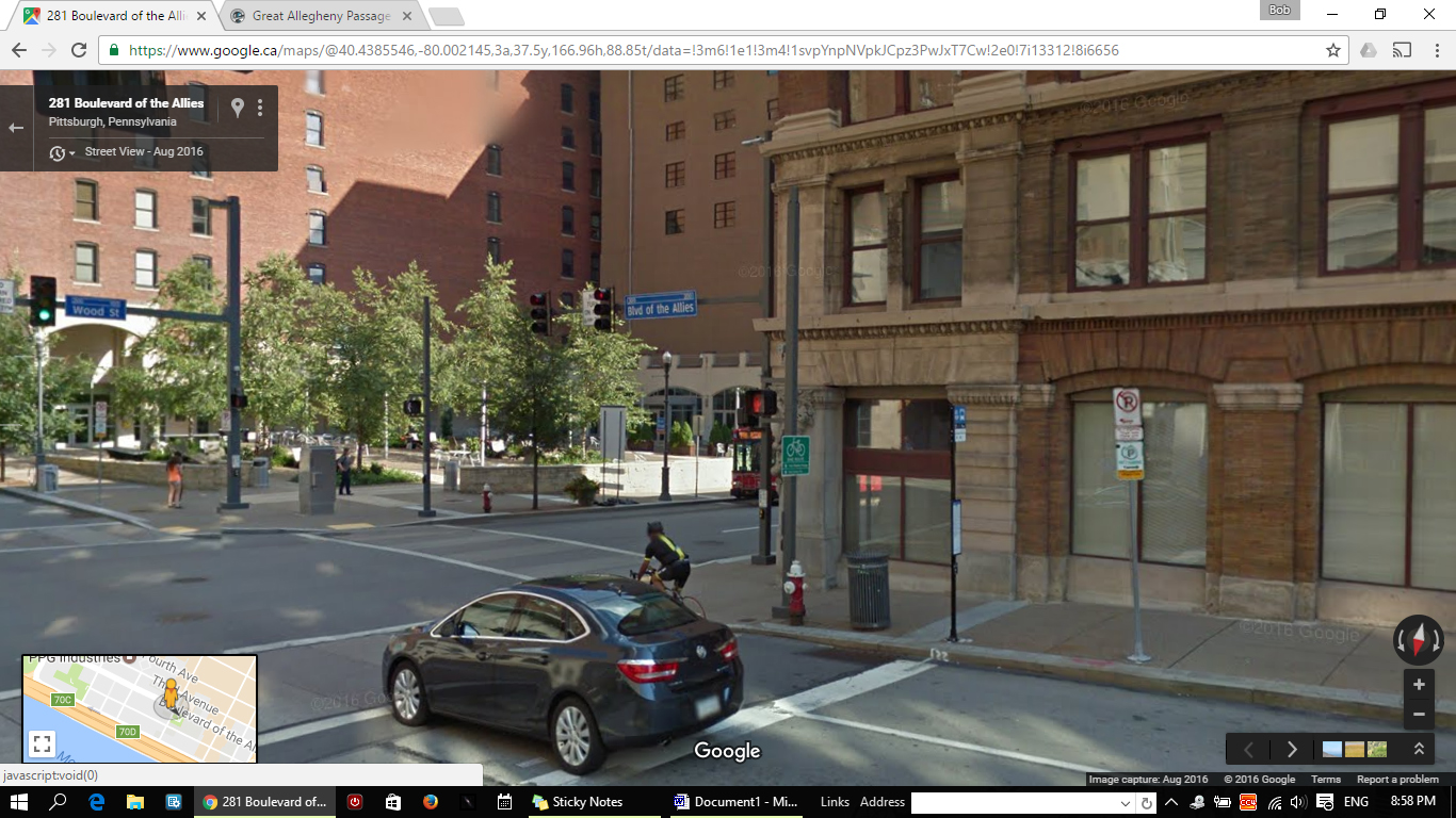
The GAP portion of the trail follows a number of abandoned railroad right of ways and it shows in some of the scenery early on. You travel over mostly smooth and level paving through Pittsburgh’s industrial heart. However, before you get to railroading you have a bit more street surfing to do. From the Boulevard of the Allies you turn right onto Grant Street, cross over to the left side sidewalk and bicycle path. Best to walk your bike the next block past First Avenue to a large compass rose imbedded in the sidewalk. Here is the true beginning of the bicycle path shown on most maps as the Three Rivers Heritage Trail. I understand that there are plans to connect this trail all the way to Point State Park but for now this is where the GAP trail starts in earnest. While we are waiting, some more signage would be nice.
The route follows the path of the Union Railroad right of way through what used to be industrial Pittsburgh. Now it is rapidly becoming an urban play space with recreation and shopping taking the place of smoke and steel. The scenery is mostly cityscape but with the Monongahela nearly always in sight. The trail crosses the Monongahela over the Hot Metal Bridge where fifteen percent of America’s steel traveled during World War Two in the form of hot molten iron going from blast furnaces of the north bank to the open hearths on the other side. Up to 180 tons per hour of molten metal made the trip during peak times. Today a smaller volume makes the trip in the form of cars and bicycles. It is hard to see that industrial might these days as softer uses replace the heat and sweat those bygone years.
The trail continues along working its way out of the city turning more residential and sometimes park-like as it goes along. It passes the site of the Homestead Steel Works famous for the Homestead Strike of 1892. It was here where on July 6th of that year, townspeople and striking steel workers faced off against armed guards from the Pinkerton Detective Agency in a day long violent battle. Who fired the first shot is still the subject of much debate but the butcher’s bill listed eleven deaths and dozens of casualties. The violence ended when the governor called in the National Guard to take over the mill and end the strike. Today the site hosts The Waterfront, a collection of restaurants, offices, big box stores and other suburban clutter. A little further on I came to the Kennywood amusement park complete with all the usual rides, slides and other gut churning attractions. As a final reminder of its industrial heritage the trail passes miles of manufacturing plants most of which seem to produce an endless supply of pipe before leaving the Monongahela to follow the Youghiogheny River eastwards.
Here things got a bit tricky as I came into McKeesport. The dedicated trail abruptly vanished from beneath my wheels and I found myself making my own way along town streets and sidewalks with few signs or other markings to guide me. The print maps lacks enough detail to show a clear route but using the logic of following the river upstream eventually got me back onto a clearly defined and marked trail but not before being again dumped back onto town streets and roadways with little more than dead reckoning to guide me. Seriously McKeesport, you need to do a bit more to keep the bikers on the right track. Still, McKeesport is trying to become more bicycle friendly but it has a ways to go.
Riding was still tricky as I left McKeesport. I crossed the Youghiogheny again and followed a bike route that roughly follows River Ridge Road merging with the road from time to time. It looks as though there are plans to make it a segregated bike path but those plans appear to be developing slowly. However, it is fair to remember that I am leaving the vicinity of the 20th largest city in America and the home to nearly 3 million people. Their primary purpose is not to accommodate recreational bicycle adventurers like me and it is well appreciated that an effort is being made to do so. Bicycle travel became easier and less confusing as I moved eastwards towards the Dravo Cemetery and a possible overnight stop.
By the time I got to Dravo Cemetery I decided that the scenery was getting too interesting and that it was far too early for me to stop. Further on I came to the site of the Port Royal Mine #2 disaster where in June of 1901 a gas explosion killed four miners with a second explosion killing the 16 named men who went in to rescue them. Another ten unnamed men may have been killed as well. The history of this and other coal mining regions is absolutely cr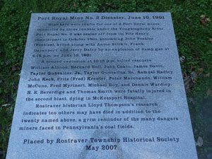 owed with tales of the many explosions and other life taking disasters that was the fate of many men and even a few women who worked underground. The foundation of the industrial world is built upon the graves those who mined the Earth for the metals and minerals that made it possible. With this cheerful thought in my mind I traveled on my gradual way up the eastern continental divide.
The trail was now crushed gravel that appeared to be mostly limestone. It is smooth and only slightly uphill. The guide book said that I had about one hundred miles of a very easy, one percent uphill grade before hitting the apex just before the Mason Dixon Line. Locomotives do not easily climb hills and for that my legs are forever grateful as I followed their former tracks. Despite my fifty pounds of gear, I made good time and found the effort quite easy. Looking at my map, I decided that I could make it to Connellsville well before dark and log a respectable sixty mile plus first day on the trail. Along the way I decided that bicyclists live not by trail mix alone so halfway between Buena Vista and West Newton I hopped off the trail and onto 1st Street and the oasis known as the Yough Twister. Cool ice cream to refresh the body and motivate the soul for the remainder of the my day. However, I had one more point of interest along my path. I got to meet Superman…sort of.
A few miles outside of Connellsville, Pa. I came across a strange site blocking the trail. It looked like a vehicle of some sorts and it appeared to be stuck between the posts of a gate designed to keep ATVs and other motorized vehicles off the GAP. I was able to work my bike around the obstruction but curiosity demanded that I investigate further. Emerging from the dim interior of his house cum rickshaw on bicycle wheels was Ras Ible; Superman on a mission. Nine tenths of the way into an epic 4000 mile journey across America from Oregon to DC this US military veteran was raising awareness of the need to legalize medical marijuana. He was doing it entirely with muscle power and he was pulling 560 pounds of living space and belongi ngs behind him. He was not even taking the easiest route and at one point floated his entire rig 50 miles down the Mississippi! Now he was stuck less than 200 miles from his finish line thwarted by a locked gate and an opening just a few inches too small to squeeze through.
Understandably, he was upset at being stuck there all day without anyone coming to unlock the gate. All day long helpful folks stopped by, made telephone calls for help, offered assistance and at one point even took a saws-all to the lock without positive results. By now Ras was hoping to make a point and refused three different attempts by me to help him around the barrier. While I have a good track record at beating various locking mechanisms the folks who designed this one wanted to make removing any part of the barrier as difficult as possible. There were no hinges that could be removed, no way to get around the shield protecting the lock and the posts were concrete filled steel. Short of a set of lock picks and some skills that I lacked, that gate was going to remain closed. With removal out of the question, I offered to help him empty his house to a point where it could be lifted by the two of us over the barrier. Ras politely declined. I then looked at any possible way around the barrier. You could possibly squeeze by on the river side of it but the bank was long and steep with a single slip spelling disaster. Still, two guys and a check rope as a safety measure could make the trip successfully. I made a trip back to Ras to pitch this idea but he was so bummed out by the lack of any official response to his plight that he again declined. It was getting late and Ras was ready to settle in for the evening so we parted company and with a last thank-you from the man, I was back on my way. I later learned that the next day he used the last alternative that I offered and worked his wagon around the dangerous side of the barrier by himself. It was at this point that someone claiming to be from the trail authority showed up to tell him he was not even allowed to use the trail. I am not sure what the basis for this prohibition would have been since there is nothing in any published rules that seems to prohibit it. However, Ras did not come all this way to be stopped by questionable authority and continued on to Washington to deliver his message. If you google his name you ca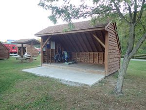 n find his full story and a detailed look at his epic adventure.
I had about an hour of daylight remaining as I rolled into Connellsville and was pleased to discover a set of very nice, conveniently placed shelters right next to the trail. Next to that was a Martin’s Supermarket with a well stocked hot food bar. No need for me to set up a tent and cook dinner after a long day on the trail. I declared a bonus and settled in for a relaxing evening. I did not even mind the trains across the river blasting their horns throughout the night. That is why God invented earplugs!
Day 2: Connellsville, Pennsylvania to Cumberland, Maryland
~ Missed Opportunity in Ohiopyle ~ Crossing the Divide ~ Under a Mountain ~ Rain and the Long Downhill Grade ~ Searching Cumberland
Day two started out great. With a good night’s sleep and a sky that promised a sunny day I packed up my gear, ate a hearty breakfast of trail mix and granola bar and put some rubber to the road. Connellsville was just waking up as I rolled through town and said goodbye to the most welcoming town thus far on my journey. But a cheery beginning does not a sunny day make and clouds heavy with the remnants of Hurricane Matthew soon filled the sky. Hurricane Matthew was a concern as I made my decision to make this trip but most models had it staying well out of my path. As the departure date approached it looked as though I had only a small chance of some light showers and a good chance of no rain at all. I should have known better.
Most of day two was fairly nice. Cloudy and a little on the cool side but not bad cycling weather by anyone’s standards. The scenery was a bit grey but overall still spectacular as I travelled over some magnificent bridges, traversing scenic gorges and streams to arrive at a double crossing of the Youghiogheny and one of the most beautiful steel bridges in the east. This beautifully engineered, seven 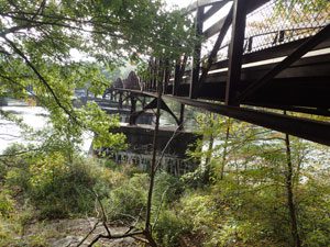 bowstring truss
 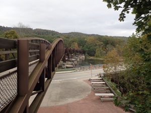 steel bridge is called the Ohiopyle Low Bridge. It spans the Youghiogheny using the same supports that in 1912 formed part of the last major railroad to be built in Pennsylvania. From then until 1975 a different structure carried the ever diminishing railroad traffic of the Western Maryland Railroad from Hancock Maryland to Connellsville, Pennsylvania. With the closing of rail service west of Hancock in 1975 the structure was abandoned and partially dismantled. In 1999 an attractive new crossing was opened to bicycle and foot travel using seven independent bowstring trusses to span the refurbished 1912 vintage pillars. This gracefully curved work of the engineering art forms an attractive gateway to the whitewater capital of Pennsylvania.
Ohiopyle is also host to the well known home designed by Frank Lloyd Wright; Fallingwater. It sits just outside of town off State Route 381. Seeing it has been on my to do list for many years and even though it was a few uphill miles out of my way, I was determined to make the trip. Unfortunately, it was not going to happen. October is one of their busiest months and their website does caution that, “Advance tickets or reservations are essential for all tours at Fallingwater.” I guess I should have planned ahead but since I was traveling by bicycle and unsure of what time or what day I would be in the area, advance ticket purchase was not an option for me. Fallingwater remains on my list of things to see and a good excuse for another trip to Ohiopyle. Even without Fallingwater, Ohiopyle is a charming place and one that I could easily convince myself to visit again. It is a very bicycle friendly place that even has a bicycle repair tool station right along the trail.
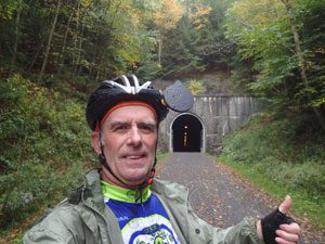
I was now into what I consider the most scenic portion of my journey. Not to take anything away from the C and O Canal towpath, few bicycle routes can compare with this roadway through the Appalachians. Nearly every mile has another vista, river crossing or spectacular view ranging from quiet forested paths to long, high bridges crossing lush valleys. Just outside of Fort Hill at mile 53 is the Pinkerton Tunnel. This is where what was once two tunnels cut through the Pinkerton Horn, a peninsula of land formed by a bend in the Casselman River. The 1884 vintage B and O tunnel was “daylighted” in 2012 and 2013, a process that involves removing a slice from the roof of the tunnel through to the top of the mountain creating an open air cut where the tunnel used to be. The newer Western Maryland Railroad tunnel was built in 1911 but abandoned with the closure of that route in 1975. It remained a deteriorating, boarded up mess until 2015 when it was fully renovated and added to the GAP trail network. Riders can now choose to cut through the mountain or take a 1.2 mile shoofly around the outside edge. I choose the more direct route through the mountain.
Next ahead was the 1908 foot long Salisbury Viaduct built 100 feet above a valley to cross the Cassleman River and preserve the 1% grade for the trains using the railway. It was intended to carry double track traffic but only one track was ever laid down. In 1975 it was abandoned with the rest of this Western Maryland RR route from Hancock to Connellsville. Today it provides one of the best wide vistas on the GAP and is a photo op for nearly every rider. It is followed a few miles further on by the shorter but very attractive Keystone Viaduct which crosses the Cassleman again before taking the trail to my highlight of the trip, the Eastern Continental Divide and the end of a one hundred mile climb.
 A one percent grade does not sound like very much. In fact, it is nearly impossible to notice as you ride or walk up or down it. However a gradual climb of nearly 1500 feet over a distance of 64 miles without any downhill for a rest can be a grind. It is a 64 mile uphill ride from Connellsville to the Eastern Continental Divide just a bit east of nearly invisible settlement of Deal on the GAP. A light rain started as I approached the divide and was joined by some fog after I passed through. This along with the grind of the steady climb that day did little to lift my spirits. I never expected magic to intervene but it did.
The Gap passes through a short tunnel to mark the divide and inside is a chart showing the change in elevation that the rider has achieved along with the downhill ride that awaits. It is spirit lifting moment to know that no matter what direction you intend to head, it is downhill for a considerable distance. Ahead lay the Big Savage Tunnel along with two others and a two percent downhill ride all the way to Cumberland. a distance of just over 23 miles of effortless riding pleasure. Goodbye gloomy day; even if the scenery is dulled, the ride will make up for it.
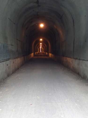 The Big Savage Tunnel is nearly two thirds of a mile long and thankfully lighted every few yards. It is cool, dark and somewhat spooky. The light at the other end is small, distant dot and the walls rough and damp. The lights give off a dull yellow glow that does little to cheer up the place. It would be a great place to stop and tell ghost stories if there was someone along to listen to them. You can read all about it on a historical sign at the north end if you like. It was tempting to spend some time looking around but it was getting late and it looked like the weather was going to get a lot worse overnight. I decided that a stay at a nice hotel or motel was in my best interest and continued on my way.
 A two percent downhill grade does not sound like much when you read about it but take my word, it makes for a great ride. Each turn of the crank takes little effort for the speed you gain and you need to be careful lest you exceed the 15 mph speed limit for bicycles on the trail. I slowed down at the Mason Dixon line for a selfie and few pictures of this famous and cleverly indicated landmark.
Frostburg was a potential hope for a place to stay but Tracfone does not seem to have service in this area and I was reluctant to leave the trail for a ride that may only find signs that read closed or no vacancy. With only 15 more downhill miles to Cumberland I decided to bet arriving after dark against a good chance of finding a warm dry place to spend the night. It was a bet that I won but only barely.
Cumberland after dark is a confusing place. The trail enters town right near the visitors center which is great except when that center is closed. Normally there is some sort of signage or other information outside of locked doors to guide a weary traveler such as myself but not here. No problem, my trusty Trail Book listed some places to stay and my Tracfone had a data plan to allow me access to Google Maps for directions. The only problem was that, once again, I did not have Tracfone service. Zero bars and nothing more that a fairly basic Trail Guide map to show me the way. Added to the fun was a light rain that began to fall. One or two wrong turns and a bit of dead reckoning brought me to doorstep of the Cumberland Ramada Inn with a walk up room price of $120.00. Tired as I was, I was not too fatigued to check if there was free wi-fi available over an unsecured router. Strangely, a reservation made just a few feet from the front desk over the hotel’s own router is twenty bucks cheaper than one made at that same front desk. The guy checking me in never said a word about my drowned rat like appearance. I guess I was not the first bad weather biker to ever check in.
One other Day 2 highlight: I met two different riders along the trail that recognized my RAGBRAI (Google it) jersey and let me know they too had done time in the corn. One had done the ride four times and the other was actually on RAGBRAI I with the organizers from the Des Moines Register. When you get on two wheels you find that you are part of a large, unofficial club of mostly friendly and helpful folks.
The C & O Canal
Day 3: Cumberland to Hancock, Maryland on the C and O 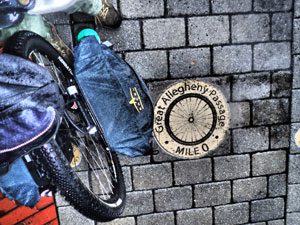
~ Rain Delay ~ Stupidity in Motion ~ Spinning in the Rain ~ A Fortunate Find ~ Last Room at the Inn
After awakening to the sound of rain pounding against my window I decided that a late start was in my best interests. Fortunately the Ramada offered a free, full, hot breakfast as part of their guest services. Plenty of eggs, bacon, sausage and hot coffee to cut through the gloom and put the body in the mood for some riding even if the weather did not. Since they offer a fairly late check out time I decided to see if I could wait out the rain. By 11am it was clear that the rain was going to outlast my patience so I packed up, strapped on and hit the trail.
The C and O Canal trail is a lot different than the GAP. Gone is the crushed limestone with hard packed dirt in its place. At least that is how it works when not soaked with a steady rain. 2016 was one of the driest years on record in this region but this weekend was doing its best to overcome those statistics. What was hard packed was now muddy with puddles that stretched a hundred feet or longer at times. I was thankful that I made a last minute decision to take my 29er mountain bike instead of the one I usually use for touring. The going was not easy but I was warm, fairly dry and definitely well rested and well fed. I was actually enjoying this wet ride and feeling pretty confident about my choice of bicycle until stupidity struck.
The C and O towpath was built to run along side of a canal designed to float boats along a level waterway using locks to lift and lower them to accommodate changes in elevation. When the canal needed to cross over a large stream or river a stone aqueduct was built to keep the canal level. There are many of these along the C and O and they have signs cautioning riders to walk their bikes across as the flat stones of the pathway can be slippery. In all my years of biking on the C and O this always struck me as an unnecessary caution and one which I and many others ignored without incident. Of course I rarely crossed an aqueduct in the rain with a heavily loaded bike. I should have listened.
I was nearly across and getting ready to go from stone back to dirt. There was a large puddle at the spot in line with the most direct route but it could be easily avoided with a small course correction before leaving the aqueduct. It all happened so fast that it is hard to reconstruct. One second I was happy and stupid on my bike and the next I was in the air, impacting off metal guard rail, landing face down on wet stone, dazed and confused. I could not breath and I was fairly sure that my ribs were cracked if not broken. I could see my bike a short distance away with most of my gear still attached. Where did I pack my cell phone and could I make a 911 call? For awhile doing anything was out of the question but after about five minutes I was able to breath without gasping but each breath, even the small ones, still hurt. I managed to roll over, get into a sitting position and consider my options.
The rain was still pouring down and it seemed quite unlikely that anyone would come along to offer assistance. I decided to wait a few more minutes and then see if I could get to my bike and find my phone. The phone was in the pack on the down side of the bike so I would need to either lift up the bike a bit or stand it up to get at the pannier. I decided to give myself a quick physical survey before trying anything else. Probing my side revealed that my ribs were sore but apparently not broken. Cracked maybe but not broken. There was no blood anywhere and everything else seemed to be undamaged. I decided to try to stand. Sharp pain when I inhaled but legs and arms appeared to be undamaged. No dizziness or other signs of concussion so that was encouraging and while still painful, breathing required less effort and gave less pain when I was upright.
It was now around 15 minutes after my accident and aside from my ribs everything else seemed O.K. Since I decided to stand my bike up, I decided to see if it was damaged. Aside from having to refasten the panniers and repacking a few items, it looked as though my body had spared the bicycle any damage. A look at my map seemed to show that the nearest road access was back towards Cumberland. Since any decision to quit my trip involved getting me and my gear to a road, I decided I could safely walk my bike to a road and then make a decision as to what to do next. However, going back to Cumberland seemed to be like giving up so I decided to see if I could make it to the nearest road along my original direction of travel since I still held out hope of completing my trip. After a few minutes of pushing my bike through the puddles and mud I decided that my feet would be dryer and more comfortable if I tried to ride a bit. Deep breaths were still not fun but I found that if I took it easy and stayed in a lower gear, riding was easier than walking. As time passed, breathing became easier and I while I still felt like a train wreck, I began to have confidence that maybe I would be able to continue. By the time I reached the next road crossing I resigned myself to an uncomfortable but manageable day on the trail.
The rain continued off and on throughout the day. At times it would stop completely and I would hope that it was over but each time it returned with renewed vigour. The trail continued to be a wet mud-fest and I began to hum, Singing in the Rain to myself changing, “singing” to “spinning.” I had the trail to myself without a single rider in either direction since leaving Cumberland and for awhile I suspected I may go an entire day without encountering another biker. This may have held true had the Washington Area Bicyclist Association not been holding their WABA in the Wild ride that weekend. Somewhere around Oldtown, Maryland I encountered the first of their ‘sweep’ riders who were heading for DC the same as I was. It was good to know that I was not the only hardcore rider on the trail. It also made me wonder where they were staying since I beginning to dread the thought of spending a damp night in a tent trying to sleep on a thin backpacking mat with some very sore ribs. It turned out that we had all picked Hancock as our stopping point and that they had already booked the local hostel. Once again my Tracfone was not getting a signal so calling ahead for a motel reservation was not an option. Time to soldier on.
As the muddy miles slipped past the periods of rain became less and less until all that remained was a dull and damp afternoon. I was still looking forward to the highlight of this leg of my trip, the Paw Paw Tunnel. This is another engineering marvel of the 19th century. Back in 1836 the builders of the canal were faced with a tough decision when canal construction encountered the rugged high cliffs of the Paw 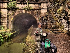 Paw bend in their path. They had the choices of hacking away at the cliffs to make a passage, damming the Potomac to create a slack-water around the cliffs or making a tunnel. Each alternative had its own problems and they eventually decided that a tunnel was the option that offered the most reliable passage and least expense to operate despite presenting a serious engineering challenge. The tunnel took 14 years to build at a cost far above the original estimate. It was an option that nearly bankrupted the canal company and caused them to end their canal in Cumberland rather than continuing on to Pittsburgh as originally planned. There were riots and bloodshed before it was opened to traffic in 1850. Today its 3118 foot length allows hikers and bikers to avoid a steep climb up and over the cliffs. The trail inside is very rough and bikers absolutely need to WALK their bikes through unless you relish a cracked skull, a swim in stagnant canal water and some quality time with the copperhead snakes that frequent this area.
The tunnel is special to me for reasons other than its interesting engineering and history. It is the place where I developed the idea for the ghostwalks I was destined to lead for many years to come. Back in 1974 I was teaching at Lemmel Junior High School on Baltimore’s west side and I hosted an after school Outdoor Activity Club. Each month I would try to organize a trip to some interesting location in the Maryland countryside and load the kids into my van for a day of adventure. It might be a day of hiking, fishing or visiting some interesting historical or environmental attraction. We had been studying American expansion in my history classes and had just watched a film on the C and O Canal. I told the kids that the canal still existed and the story about how it had become a national park and a great place to bicycle without having to worry about cars. At our next club meeting the kids were keen to visit the canal and they wanted to make it an overnight bicycle trip. This took a lot of extra planning and effort. First, I had to scrape together enough parts and get the kids to bring their bikes to the school for a few evening of much needed repairs. I also had to rebuild a couple of bikes rescued from the scrap metal pile of my local landfill to lend to a couple of the kids. Then I had to borrow enough tents and packs to accommodate the group. Thankfully my brother Jerry had some tents which along with the other equipment I had scrounged made the trip possible.
Finally, the big day came and we were off to our starting point at Little Orleans. throughout that first day on the trail I would overhear some of the kids talking about how they were going to play some pranks on their schoolmates that evening. Some of these pranks involved sabotaging tents and other mischief. I had visions of torn tents and wrecked borrowed gear that was beyond the means of my teacher’s salary to replace. Baltimore of 1974 was not known for its overly generous teacher’s salaries. A solution was need to quell the impending good natured violence.
We camped that evening just outside the entrance to the Paw Paw Tunnel. The tunnel itself is fairly spooky and these were city kids not used to sleeping outdoors in tents so I decided to make that work for me. After dinner I announced we were going to take a walk in the dark, no flashlights allowed except my own, to experience the sounds of life in the countryside. We walked for a bit quietly listening to the night sounds as I explained what we were hearing. I was taking a circular route I had found on a prior visit and one that would take us through a abandoned railroad tunnel and past an old graveyard. I stopped the group opposite the graveyard and turned on my flashlight to let them have a look around. “Anybody want to hear a ghost story,” I asked. Of course they did. This was fun and no one wanted to appear to be afraid in front of their buddies. Throughout that day I had planned out a couple of stories in my mind with one involving the ghost of a Confederate soldier that was said to hang out around the Paw Paw Tunnel. I saved this story for last and it was a quiet, reflective walk back to our campsite afterwards. The kids could not wait to get into the safety of their tents and pull the covers over their heads. No sight or sound was heard from those tents until the net morning.
On our next trip the kids insisted that we do what they referred to as, “one of those ghostwalks” again. They became a staple of every trip thereafter and something I incorporated into a weekly activity at a campground I owned years after I left teaching. Over the years I have written or just made up on the spot a few hundred tales of a ghostly nature. Most are absurd, some are funny but some are still just plain scary. Every once in a while when the mood is right and I am with the right group I still take a ghostwalk and tell some tales.
With the tunnel behind me my thoughts returned to the here and now. My breathing was now very much improved but my body was beginning to long for this day to come to an end. While the trail was slowly draining there was still far too much mud for the ride to be enjoyable. I had just crossed the Sideling Creek Aqueduct (walking my bike across) and had come up on canal Lock #56 when I glanced at a sign indicating the beginning of the Western Maryland Rail Trail off to my left. I had been over part of that trail south of Hancock earlier in the year and knew that it was paved with asphalt. I made an instant decision to turn my mud caked bike around and take a break from the C and O mud-a-thon. I must have said something out loud because a young couple on their bikes who were just ahead of me on the trail turned around and asked, “there is a paved trail over there?” I explained that the parallel Western Maryland Rail Trail was definitely paved east of Hancock and that I was reasonable sure that this portion was paved as well. Together, the three of us decided it was worth a look.
It was a stroke of luck that they joined me on that alternate route. A few miles down that trail I found my way blocked by a large tree that had come down in the heavy winds that day completely blocking the trail and any way around it. With my injured ribs it would have taken me a long and painful time to move my bike and gear over this obstruction but with their help I was easily across. We were not traveling at the same pace so we quickly parted company only to run into each other three more times over the next 24 hours.
The WMRT is a great bike path and Washington County is to be praised for the decision to create it. It offers a different experience than the canal trail that parallels it and is a pleasure to ride with any sort of bicycle. For me it was a relief to be off the mud and on to some easier riding just when I was getting a the lowest ebb of my energy. I actually felt somewhat refreshed as I rolled into Hancock and began my search for a place to stay.
Since there was still no cell phone service for me I had no choice but to go to each possible place to stay in person. I knew the hostel was full and the America’s Best Value Inn had the No Vacancy sign lit up. I remembered reading that the C and O Bicycle Shop had a couple of rooms they rented to cyclists so I headed there with a hope that they would still be open and have something to offer. They were open but I learned that even with the tail end of a hurricane in the area, it was a busy weekend in Hancock. All their rooms were booked. However, the owner offered to call around for me and found the last remaining room at the Super 8. It was a smoking room but I did not care. It was warm, dry and had a soft bed. The woman at the front desk even went out of her way to air out the room and try to freshen it up before I checked in. They even had a convenient hose outside that allowed me to hose off miles of mud from every part of my bike, gear and body. As I settled in for the night I notice a number of other riders arriving with mud crusted gear and a look of relief on their faces. Hancock proved to be a very friendly place and one eager to accommodate the bikers who travel the two paths near their town. It may be trite but I think this proves that if you build it, they will come…and stay and spend and enjoy!
Day 4: Hancock to Indian Flats
~ High Spirits ~ Sunshine ~ Walking the Dogs
It is amazing what a comfortable night’s sleep can do. At first it was hard for me to find a horizontal position that was not painful but with some careful pillow placement and the help of a really comfortable mattress I finally achieved unconsciousness. The next morning I awoke with far less pain and much improved spirits. After a quick breakfast courtesy of Super 8 it was time to pack up and get back on the trail. The morning was still a bit gloomy but there was no rain and while chilly, there were still a few more miles of the asphalt WMRT before I would have to venture back onto the C and O. When I did rejoin the C and O near Big Pool I found it to be considerably dryer and far less muddy than the day before. With a little careful riding I found I could easily avoid most of the mud and larger puddles. My pace was back to normal and the miles began to fly by.
The trail was a lot busier this day. I started by again meeting the nice couple that helped me around the tree the day before. They were heading for Harper’s Ferry and we wished each other a safe journey. Other riders were beginning to join the trail along with quite a few walkers wherever the trail neared a place with road access. Many of the bikers were just out for a nice Sunday ride but there were plenty of through riders, some as loaded down with gear as I was, heading in both directions. It is interesting to note that you see people of all ages and abilities on this popular trail and all seem to be enjoying this great resource. At nearly 65 years old, I was far from the oldest through rider on the trail that weekend. Everyone I met either offered a cheerful hello or the biker’s salute in passing. When I stopped there was always an exchange of information and trail tales with the riders I met. People on bicycles undergo a metamorphous into a different creature than the one who sits behind the wheel of car. There is no such thing as road rage to a bicyclist on a dedicated path with other bikers.
You may wonder why this journal does not spend much time on some of the historic sites along this day’s journey. Growing up spending my young adult years with the Potomac River valley as my playground had jaded me into not seeing any reason to stop at the many places I had visited many times over numerous other visits. However, those reading this will certainly want to check out such sites as the Antietam battlefield, home to one of America’s bloodiest and significant days. You also need to make the trip up the stairway and across the bridge to Harper’s Ferry, West Virginia. A charming town in its own right, this historic village was the scene of John Brown’s raid and a lot of Civil War action. It has been nicely restored and is a step back in time. Weekdays are far less busy than weekends especially if you expect to grab a meal at one its many restaurants. It is also the starting point for October’s Freedom’s Run Marathon one of the best running races in the U.S.A.
The area across from Harper’s Ferry is known as Sandy Hook and I remember it for providing some great smallmouth bass fishing with my brother Jerry and friend Jim. It was also the scene of many bicycle trips with kids from my outdoor activity club and is where I proposed to my wife Christine. Even though I had run over the same dirt just a year before on Freedom’s Run, I took a few moments to savour some memories before moving on. If you pass through on a weekend be prepared to go slow as this is only second to the area around Great Falls for being the busiest spot on the C and O. Besides, the scenery is fantastic and you will want to take some time to enjoy it.
The other thing I noticed about the trail from Hancock on to DC is that for a couple of miles on either side of any place with road access or parking near the trail you will find people walking dogs. It must be the number one local pastime in those areas. You might expect this to create a problem for biker and dog walker coexistence but this is not so. Every approaching dog walker I encountered was careful to shorten their leash and keep their pooch under control. Just remember that on a bicycle you are fairly quiet and if you are coming up behind someone walking a dog it is good idea to ring your bell or otherwise alert them to your passing. People walking or running with ear buds plugged in pose a far greater risk for collisions and it is up to the biker to slow down, give notice (or try to) and be responsible for avoiding potential accidents.
With this being my first night camping since my accident I decided to call it an early day and stopped at Indian Flats, one of the many camping sites maintained by the US Park Service along the trail. Each site has a green rocket (port-a-potty) and a pump to supply water. This water is treated with iodine to kill bacteria and some folks can not drink it. I never experienced any problem but riders should be aware that the park service is considering closing down these wells and we may have to source our own water in the future. There is also a program underway to require reservations, registration and fees for some campsites along the trail. Riders should check the C and O website for the latest information on trail conditions and regulations. You can find it at www.nps.gov/choh/index.htm
Last Day: Indian Flats to Washington, D.C.
~ White’s Ferry ~ Great Falls ~ Crowded Path ~ Disappearing Towpath ~The Search for Mile Zero
My last morning started with a warm sunny glow and a truck at 6am to pump out the green rocket. I doubt they had much to pump as this port-a-potty was sitting at a 15 degree angle making a visit like a visit to the crooked room at a carnival fun house.
If you are looking at hooking over to Virginia and taking one that state’s many bicycle routes into Washington you can hop off the C and O at White’s Ferry and take this still operating ferry over to the other side of the river for a small fee. They also have a restaurant that serves a killer breakfast. White’s Ferry in very near the site of White’s Ford where Robert E. Lee led part of his army in September 1862 on his way to take the war to the north. He never made it very far due to a copy of his orders falling into Union hands and tipping off General McClellan to the fact that he had divided his forces and left himself open to destruction. Only McClellen’s poor leadership, Lee’s audacity and some hard marching and fighting by the Confederates prevented an early end to the Civil War.
Further down the tow path you cross the great Monocacy Aqueduct where the canal crosses over one of the larger rivers feeding into the Potomac. This aqueduct has been carefully restored and is another work of engineering beauty. From here you can make a side trip to one of the lesser known but important battles of the Civil War; the Battle of the Monocacy. Today there are efforts ongoing to preserve this battlefield which represents the last and most successful Confederate invasion of the North.
During the last months of the war General Grant had Lee’s Army of Northern Virginia bottled up in Petersburg, Virginia. Confederate General Jubal Early managed to slip away with a force that grew to around 16,000 men as it entered the Maryland countryside in an attempt to divert Grant’s attentions away from Petersburg. This move was unanticipated by Grant and there were only around 2,300 men, mostly short term enlistments, between Early and Washington, DC. Grant had to scramble to move men to defend the capital lest Early’s force invade and capture it with little opposition. Standing in his way was General Lew Wallace and a force that he managed to increase to around 6,800 men and assemble at an important railroad junction just outside of Frederick, Maryland. On July 9th, 1864 Wallace’s force engaged in battle with Early and basically fought a holding action throughout that day before being forced to retreat via railroad back towards Baltimore. This left Early’s way to Washington largely open and unopposed. However, the delay and Grant’s use of the well developed railroad and shipping infrastructure of the area, allowed him to reposition a sufficient force in Early’s path but not before Early was within sight of the US Capital dome. Early’s attack on Fort Stevens, just outside of the city, was unsuccessful but nearly gave Confederate sharpshooters President Lincoln as a target. Lincoln had traveled to Fort Stevens to observe the battle and was standing on a parapet in full view and range of Confederate marksmen when a Union surgeon standing next to him was hit by rifle fire. Early broke off the attach the next day and returned to Virginia via White’s Ford along with a supply train of booty and the knowledge that he had given Old Abe a serious scare. (An interesting sidebar: Lew Wallace, the union general who delayed Jubal Early’s invasion, may be better know for his work after the war. He was the author of historical novel, Ben Hur.
The closer you get to Washington the busier the trail becomes and no place more so than at Great Falls. This is a destination for tour busses, day visitors, artists and the teeming masses yearning to see the falls. It is far safer to walk your bike through this area unless you come early in the morning or very late in the 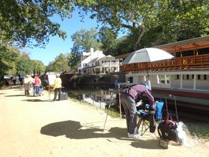 day. It is a most beautiful location with the canal restored to all its former glory along with locks, canal keeper’s house and a well maintained pathway. You can even take a canal boat ride on the Charles F. Mercer with mules to pull it along the canal and accompanied by a park ranger in period clothing. The falls themselves are well worth a look but be sure to keep well back from the edge. The rocks can be quite slippery and more than one person has learned this lesson posthumously. Don’t be fooled if the water does not appear to be particularly dangerous. The currents and hydraulics are far stronger than they appear on the surface and even the best swimmers drown here on a regular basis.
You need to travel a mile or two past the Great Falls area before you can safely return to a normal riding tempo so stay alert and be aware that there are school children and foreign visitors aplenty. Most do not expect to see bicycles on the path and will either not hear, not care or not understand your dinging bell. They have the right of way.
For a while the tow path returns to its more rustic roots and it is hard to imagine that you are bicycling through one of the more intensely developed regions of the eastern United States. However, this illusion disappears quickly as you approach the Georgetown terminus of the canal. One last point of note along the way is the location of the old Glen Echo Amusement Park. The park was once a fine example of the numerous amusement parks that dotted the countryside outside of many major cities. Here you would have found the Spanish Ballroom with its 7500 square foot dance floor and the usual amusements such as the Coaster Dip, the Derby Racer and the Tunnel of Love. It closed in 1968 but was taken over by the National Park Service and now serves as an important center for the visual and performing arts.
Not long after you pass under the Chain Bridge the C and O crosses paths with the Capital Crescent Trail. There is a connecting path uphill from the C and O to the Capital Crescent where it passes over the C and O via a bridge. This trail parallels the C and O nearly all the way to its end and serves as a high speed alternative to the canal trail. Be warned; this trail is a commuter route for cyclists in the DC area and it can become crowed at times but this is true for the C and O as well. Just be sure to watch your speed and ride with awareness and courtesy. If you decide to take the Capital Crescent trail all the way to its end you need to understand that getting back up to the C and O canal trail will require you to walk your bike uphill to the C and O. There may be a better way to do this but the best I could find was a somewhat unofficial and rough dirt path. You may find it easier to stay on the C and O but the CCT does offer some other interesting destinations if you decide to follow it in the opposite direction as it connects with other DC trails and bicycle routes. You can find additional information at www.bikewashington.org or www.cctrail.org.
As you get into the heart of Georgetown you discover that the C and O canal trail ends with more of a whimper than a bang. I came along the south side of the canal where the tow path had travelled since well before Great Falls. I was not expecting it to cross over to the north side so I either missed seeing and directional signs or there were none to be seen. One moment it was there, the next it disappeared into city streets and brick buildings. I could easily see the canal continuing on but where was the trail? Where was the elusive Mile Zero? I found myself in a lovely cobblestone plaza surrounded by mountains of red brick walls. I should have crossed over to the north side of the canal but the path in that area was so narrow that I doubted a bicycle and a pedestrian could safely pass one another without someone going 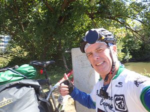 into the canal. Instead I took to the city streets keeping as close to the canal as I could. Sometimes I found a bit of tow path that seemed bike worthy and I followed it for as long as I could but eventually I found myself on the bicycle path paralleling the Rock Creek and Potomac Parkway. Where was Mile zero? Using a bit of dead reckoning I followed the path south and stumbled into Rock Creek Park. Knowing that the canal begins at the Potomac River near Rock Creek, through trial and error, found my way to a nice little plaza at the end of 30th Street NW. From there it was a short ride to the east where I could see the Thompson Boat Center where my guide book said I could find the Mile Zero post. I found that I had to actually go through the boat center’s parking lot and along the Potomac side of their property to come to a grassy area and a dirt path leading around a tall wooden fence to a foot bridge across a very dilapidated canal section. Here at last was the elusive marker for Mile Zero. If you want to see a video I wished I knew about beforehand, check out this YouTube link: https://www.youtube.com/watch?v=9kzs51zRsSY.
Conclusion: Would I Do It Again?
The answer to this obvious question is a definite yes! The trip was enjoyable even if I had to do it solo and with a day of bad weather and two days of riding with cracked ribs. If that is not an endorsement, what would be? I do plan to make the journey again and maybe in the opposite direction this time. I would also hope to do it with a fellow rider or two. Camping sites, water and other necessities were easy to find and if you decided to make it a luxury excursion, there are plenty of roofed accommodations available at commercial hotels, bed and breakfasts, hostels and Airbnb.com. Personally, I recommend the camping experience but not the cracked ribs.
Bob Peltzer ~ Eganville, Ontario, Canada ~ 2016